Sunday, September 24, 2006
...across the fields...
So, our pipeline has crossed into the Crown Estate land to the east of the depot. If our pipeline is to go south to Heathrow then it must logically cross the next road south, unless it snakes back across Green Lane and towards the built up areas of Hemel(for some inexplicable reason) which it doesn't, because there are no markers across Green Lane south of the roundabout. However, if you are driving on the M1 and leave at junction 8 for Hemel Hempstead to get on the A414, the link road off the motorway [shown on map2] is crossed by the pipeline at the point shown on map3. I don't have any pictures of this yet. However, as I mentioned previously they are presently widening the M1 from junction 8 upto Luton airport at J10a. There appears to be a small village of temporary accommodation for the workers in the Crown Estate land. They have built a brand new access road to this 'village' from the roundabout off Green Lane. Also, a new access road to the Breakspears Farm road has been constructed.
Aha! So we know that the pipeline crosses that land, so each of those new roads must run perpendicular to the pipeline - and thus should be marked you would have thought. In fact, these should be the two newest additions to the pipeline marker family.
So I snuck up the first service road, off the first roundabout in Green Lane, which was covered in the mud from heavy plant machinery. And low and behold:
 pic4
pic4
Bless 'em a brand new aerial marker post! [see map3]
 pic 5
pic 5
and on the other side of the road a little sign, but no marker post as such. Note the pink/red post painted and whacked into the ground to mark the pipelines. No details of what is actually down there - but you are left in no doubt that there is something there!
So onto Breakspear Farm - bit further up the path, and I marked on my map the exact spot on the earth's surface thanks to the ol' Sat Nav. Felt very cheeky driving up this path, however you are not really overlooke d by the Farmhouse, it was early, and I saw no one else.
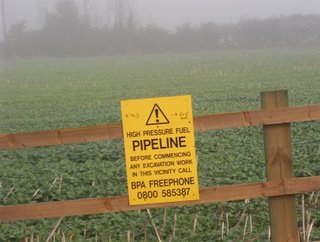 As I said earlier the track to the Farm has been widened I think recently and another yellow sign attached to the new fence. This time if you look carefully, the information which is normally on the little marker posts is written on the sign.
14" TM/1 --> 6"+8" WLPS.
pic6

pic 7
The same information is written on the sign across the road on the southern side. But the most 'interesting' (and remember this is the dour world of pipelines for goodness sake) is what you can see in the background. If you look closely, you can see a gap in the hedgerow and another yellow sign (facing into the field). This is the link road off j8 of the M1 and it is the point at which the pipelines cross that road.

pic 8
I took another shot of the distant yellow sign - it is not going to win any awards but I think it is a bit clearer than the last one. Click on the picture to see it in greater detail (if you dare).
 map 3 - showing the path of the pipeline across the field.
Thus the first section of our journey is complete, we see where the pipeline leaves the depot, and the direction of travel out south east across the fields and over the link road from the M1.
Where does it go next....? The suspense must be driving you mad (not). ¶ 12:57 pm
Aha! So we know that the pipeline crosses that land, so each of those new roads must run perpendicular to the pipeline - and thus should be marked you would have thought. In fact, these should be the two newest additions to the pipeline marker family.
So I snuck up the first service road, off the first roundabout in Green Lane, which was covered in the mud from heavy plant machinery. And low and behold:
 pic4
pic4Bless 'em a brand new aerial marker post! [see map3]
 pic 5
pic 5and on the other side of the road a little sign, but no marker post as such. Note the pink/red post painted and whacked into the ground to mark the pipelines. No details of what is actually down there - but you are left in no doubt that there is something there!
So onto Breakspear Farm - bit further up the path, and I marked on my map the exact spot on the earth's surface thanks to the ol' Sat Nav. Felt very cheeky driving up this path, however you are not really overlooke d by the Farmhouse, it was early, and I saw no one else.
 As I said earlier the track to the Farm has been widened I think recently and another yellow sign attached to the new fence. This time if you look carefully, the information which is normally on the little marker posts is written on the sign.
14" TM/1 --> 6"+8" WLPS.
pic6

pic 7
The same information is written on the sign across the road on the southern side. But the most 'interesting' (and remember this is the dour world of pipelines for goodness sake) is what you can see in the background. If you look closely, you can see a gap in the hedgerow and another yellow sign (facing into the field). This is the link road off j8 of the M1 and it is the point at which the pipelines cross that road.

pic 8
I took another shot of the distant yellow sign - it is not going to win any awards but I think it is a bit clearer than the last one. Click on the picture to see it in greater detail (if you dare).
 map 3 - showing the path of the pipeline across the field.
Thus the first section of our journey is complete, we see where the pipeline leaves the depot, and the direction of travel out south east across the fields and over the link road from the M1.
Where does it go next....? The suspense must be driving you mad (not). ¶ 12:57 pm
