As I said in the description above Croxley is due south of Buncefield (see map under 14th Sept 06) so my first inkling was that the pipeline would be direct, especially as it was shown as a direct line on the news programme and newspapers at the time. However, starting out where the pipeline crosses the M1 j8 spur road it was apparent pretty quickly that the route was not direct but that it went south for a bit, turned sharp west and then wended its way through the sleepy bits of the countryside not far from where I live.
I started 'tracing' the pipeline at the start of 2006 - spending a couple of hours here and there with a 1:25000 explorer o/s map, my sat nav and a pencil. In a couple of months I had traced the whole route, as it meanders through the Herts and Bucks countryside and crosses the M4 and M25 in its latter stages. I had located it by finding where it intersects the roads that it must inevitably cross moving from Buncefield to Heathrow. This gave me the general route, which I have plotted on a map (which I will post later) I hadn't traced where the line crosses fields or public footpaths, and I have started doing that now. I thought it time to share my experiences, and to demonstatrate what a saddo I am!
The pipeline in question is run by the WLPS (West London Pipeline and Storage) a subsection of the BPA (British Pipelines Agency - a joint venture between BP oil UK and Shell UK) which forms part of a network of high pressure pipelines across the UK which connect storage depots to terminals airports and government depots.
I have been helped in my 'quest' by the Linewatch website and by various other websites, which I will link once I discover how(!) That's it for now. I will update this as I go.
As ever my apologies to anyone working in the oil industry who finds my conjecture laughable and my acknowledgements to the Ordnance Survey and Multimap for the maps I have used/will use.
I have postdated this post to keep it as an introduction to the website. ¶ 3:30 pm 0 comments

map 7
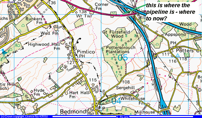
We have the choice of the nw-se Hemel to Bedmond road, or the sw-ne Bedmond to M1 (then Potters Crouch road). Sensibly I drove towards Bedmond first, via Pimlico, and what should I find just before Pimlico - but, yes, our friend the pipelines again. (you must be leaping out of your chairs with ecstasy - oh yes, I can tell).

pic 12 - bingo - there is our friend again. Note the pipeline indicators both showing away from Buncefield.

pic 12a - on the other (western) side of the road - the posts themselves are a bit overexposed, so fortunately I took a close up. (pic 12b)

pic 12b - close up.
Pimlico was a funny old place. It was a fairly damp September Sunday morning and it must be odd to have this bloke randomly walking up and down your pavements taking pictures of pipeline markers. I thought I would poke around behind the markers in pic 12 as there were a load of small bushes then a few trees and a view of the fields beyond. I went as far as the barbed wire fence and had a peer but couldn't see anything that would indicate a pipeline. I managed to take pic 13 quickly, because at that point I could hear voices. No, it wasn't the madness catching up with me but a couple of gents out on a Sunday morning stroll. I poked my head out of the undergrowth and they stopped talking. What should I do - stay where I was and just stand there in the bushes as they passed? Or nip out of the bushes in front of them? I did the latter, God only knows what they must have thought I was doing in the bushes. At best they thought I nipped in there for a piss. When I did walk out in front of them I was about 8 feet in front of them, and they remained silent for the next 100 yards as I walked in front of them, maintaining the 8ft gap, but shuffling nervously. I crossed the road to where my car was and their conversation resumed immediately.
Anyway pic 13 & 13a shows the hurried pics I took...

pic13

pic 13a
So, I have marked the point where the pipeline crosses the road in Pimlico on map 8. I went back and walked on the footpaths shown on the map, and, despite some lovely views there was no evidence of the pipeline, apart from a couple of possible gaps in hedges.
Despite (or perhaps because of) my embarrassing experience a few moments earlier, I had another look on the map to see which public footpaths would cross the pipeline, again just to see if there was any evidence other than than when the pipeline crosses the road.
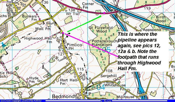
map 8
There is a footpath (and it is much more visible on the 1:25 000 scale) that runs se-nw through Highwood Hall Farm. Initially it crosses a nice little field at an angle, then you go over a style in to the drive of the farmhouse, and if you didn't feel conspicuous already you do now. The footpath is poorly marked from here and you guess left. I went up the drive for about 50 yards and then the footpath turns a corner and you run into a small courtyard and the path stops. There is a little stile but it crosses a bit of hardboard which is too high to clamber across. I peered over and the footpath goes across a stables. There is a caravan there which was clearly occupied. A young woman led a pony with a child on its back across the yard in front of the stables, watched by a small gathering of other women. Somewhere around here a pipeline with the fuel that goes into Heathrow's and Gatwick's aeroplanes runs. I couldn't see any evidence of it and I don't think that the lives of the horsey people would have been enhanced by me attempting to clamber over the hardboard and then presenting myself in the stables. Discretion was indeed the better part of valour. I had every right to walk across the yard but would have felt even odder than I already did in doing so. ¶ 10:36 pm 0 comments
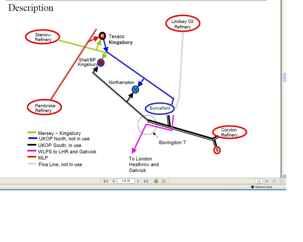
I have found an excellent document which shows that there is a spur from Thameside aka Coryton to Buncefield, whilst the remainder of the pipeline continues to Kingsbury. Therefore when you are looking at the pipeline spur, then the arrows are going to point towards Buncefield. Whilst not on the spur the directional indicator whilst the remainder of the arrows are going to point away from the Buncefield terminal.
This would mean that the 'T'-junction spur will occur between the two marker posts with different directions on. The diagram below shows it well. Now just to locate the line coming in from the east and to work out where the spur is.
 ¶ 12:30 am 0 comments


map 4
Map 4 shows us its potential journey. It will either cross the road by Westwick Row (called unsurprisingly Westwick Row) or the A4147 Hemel to St Albans road.
The only way of being certain was to drive all the way down Westwick Row and then to turn left onto the surprisingly busy A4147.
Nothing down the medieval Westwick Row, but then, low and behold, shortly before it crosses the M1 there is the pipeline. Pic 8 and 8a show the marker posts, map 5 shows the location.

map 5

pic 8 - these are the markers on the northern side of the A4147 - spot the CP post - more on that below. Note the UKOP pipeline marker on the left. The directional indictator shows it is running in the opposite direction to all of the others. From memory, this is the only one showing the flow towards Buncefield. According to the Linewatch website, this is the actual direction of the flow, as it should run from the Kingsbury terminal to Buncefield. If this is the case however why do all of the other UKOP pipeline markers show the flow going to Kingsbury? I am really not sure about this. The first Buncefield enquiry neatly summarises all of the pipes and what goes where:
To Buncefield:
- 10" Finaline pipeline from Lindsey
- 10" Pipeline from Merseyside
- 14" From Thames (Coryton as it is known) to Kingsbury terminal (in Warwickshire) with a spur line to Buncefield - aha! This is clearly our one. We will see where the spur comes from and splits later on, but this does suggest that the pipeline direction should be to Buncefield rather than away, opposite to the two lines going to Heathrow. Another inconsistency - or gap in knowledge - the 14" pipeline markers to/from Buncefield are described in the report(s) as the T/K line (Thameside - Kingsbury??) whereas on all of the markers it is marked as T/M (Thameside -??? )
The T/M line is also shown as being on leg 1A (newly placed stickers - I am sure it was just 1 the first time I checked earlier in 2006) and that it is 88.8km long. Well I wonder if this spur goes to Northampton? This is about 90km away from this point.
The third report describes the split as: "14” pipeline from Thameside via a tee junction close to the site – the Hemel Tee (T/K South), which terminates in the BPA main site."

pic 8a southside - was dodging the cars and the boy was in the car, so I couldn't really cross the road to see if there were marker posts there too.
Now, back to the CP post we saw in pic8. Any ideas what that stands for? Well, after digging around a bit (not literally) I found it stands for Cathodic Protection, which to cut a very long story short - aims to prevent corrosion on the buried pipeline. Another explanation is here.
So now we know where the pipeline enters and exits this stretch. Is there any evidence of it 'on the ground' as it were? We can see from the map that a public footpath crosses the field that the pipeline must cross somewhere. I wondered if it would be marked any where - would there be an ariel marker post at field edges/boundaries? As there were other walkers around (bizarrely) and Pipeline Pete jnr was fading fast, I had limited scope for going 'off piste'. So I walked the path and looked for any posts, or failing that some obvious gaps in hedgerow or any hints at all.

pic 9 - here is a big blank path which bisects the footpath - no clues as to being a pipeline though, and crucially, it does not abut the motorway, which would be the logical (?? who am I to say?) route to put it.
I carried on - and at the end of the footpath, where it ends and meets the M1 is a newly built fence. Beyond the fence was a relatively recent mounds of earth, presumably again to do with the widening. One thing I noticed at the time, and thinking about it now it is pretty obvious, is there was a pink tag on one of the fence posts, about 30 yards north of the intersection with the footpath and the M1. Surely this is indicating that the pipeline is running beneath or near. The fence in question is shown in pic10.
 pic 10

pic11 - this is the view from the opposite direction - the fence in pic10 continues on the left of the picture, just out of view. You can see one of the overhead gantries on the M1 though, if that's any consolation.
If I were to walk the 'fence' in that field, I suspect I might see a few more fence posts with pink paint on - if I were to guess - I would say the pipeline runs close to the M1 - my pure conjecture is shown in map 6, below:

map 6 ¶ 3:39 pm 0 comments
Aha! So we know that the pipeline crosses that land, so each of those new roads must run perpendicular to the pipeline - and thus should be marked you would have thought. In fact, these should be the two newest additions to the pipeline marker family.
So I snuck up the first service road, off the first roundabout in Green Lane, which was covered in the mud from heavy plant machinery. And low and behold:
 pic4
pic4Bless 'em a brand new aerial marker post! [see map3]
 pic 5
pic 5and on the other side of the road a little sign, but no marker post as such. Note the pink/red post painted and whacked into the ground to mark the pipelines. No details of what is actually down there - but you are left in no doubt that there is something there!
So onto Breakspear Farm - bit further up the path, and I marked on my map the exact spot on the earth's surface thanks to the ol' Sat Nav. Felt very cheeky driving up this path, however you are not really overlooke d by the Farmhouse, it was early, and I saw no one else.
 As I said earlier the track to the Farm has been widened I think recently and another yellow sign attached to the new fence. This time if you look carefully, the information which is normally on the little marker posts is written on the sign.
14" TM/1 --> 6"+8" WLPS.
pic6

pic 7
The same information is written on the sign across the road on the southern side. But the most 'interesting' (and remember this is the dour world of pipelines for goodness sake) is what you can see in the background. If you look closely, you can see a gap in the hedgerow and another yellow sign (facing into the field). This is the link road off j8 of the M1 and it is the point at which the pipelines cross that road.

pic 8
I took another shot of the distant yellow sign - it is not going to win any awards but I think it is a bit clearer than the last one. Click on the picture to see it in greater detail (if you dare).
 map 3 - showing the path of the pipeline across the field.
Thus the first section of our journey is complete, we see where the pipeline leaves the depot, and the direction of travel out south east across the fields and over the link road from the M1.
Where does it go next....? The suspense must be driving you mad (not). ¶ 12:57 pm 0 comments
We drove up to the depot first thing in the morning, it was shrouded in mist, and I must admit I did feel a bit dodgy, parking up and taking pics there. To be honest I always feel a bit furtive and dodgy doing this. What must people think this bloke standing there with his camera and his sat nav, taking pics of marker posts? More of this later.
 So, here's the main entrance to the depot [pic1] , and there are two others on the western side I think. Note the security cameras (not pointing at me) and the depot was open, but no one was about. The map shows a left turn at the top of the depot, but this was blocked off [as shown in map1] For more about the depot itself please see this emergency plan document.
Map 1.
Here's the depot. Where do the pipes come in and out? You would think that there would be some sort of sign saying "the start of the trek to Heathrow" - but no. Actually, the first pipeline marker you come across isn't our one at all, but the one I previously referred to, which is bringing oil in from the refinery at Killingholme. [pic2]. Slightly further up the road [see map 2] our pipeline starts. And whilst the Total line coming in to the depot, makes a bit of a song and a dance about it (that is as much of a song and a dance as you get in the dour world of oil pipelines) our one is just marked with one pink- capped aerial post and no marker posts that I could see.
map 2


pic2 - Killingholme to Buncefield pipeline coming in to the depot.

pic 2a - same pipeline, but the other (western) side of the road - not the directional indicator, ie the flow of the oil is away from the viewer, that the pipe is 10" wide and that this leg of the journey is 104.6km long. I'm not sure about the S at this stage, but the L- marking indicates that the pipeline contains liquid.
 pic3 - finally, a bit further south we come across our pipeline for the first time. I'm not getting misty-eyed or anything, it was 8:30 in the morning and September, so it was misty on that morning. Note the cobwebs with the dew on them too. This is not marked on the other side of the road like the total one was and is more or less opposite the depot entrance shown in pic1.
So - the pipeline has left the depot (I mean pipeline as a generic term for the three pipes: two marked WLPS bound for Heathrow an one marked UKOP which may or may not be going to Kingsbury or coming from Kingsbury, don't know yet) , which is on the eastern side of Hemel and has entered Crown Estate farmland to the east of the depot, and is presently running east. That pipeline has got to go to Heathrow first (the Kingsbury one doesn't but bear with me for now until we get to Bovingdon where things get 'interesting'), so I guess it had better turn south, which it must do pretty sharpish, as the next road incursion [map3] has it going virtually north-south across the roads.
[As ever: my thanks to the ordnance survey for their wonderful maps, and to multimap for showing them for free. Also, I am no expert on pipelines to any degree whatsoever, all I know is what I have picked up from the internet and what I have spotted whilst out and about. Please, if you are involved in the oil industry, or have any knowledge of the WLPS please leave a comment and point out any glaring errors or areas of over-asumption I may have made!!] ¶ 1:05 pm 0 comments

There you go (you might have to click on the map to see it in detail) we are just under 8 miles south of the Buncefield depot (correct name: Hertfordshire Oil Storage Ltd)- 8 miles might seem a fair distance, but the blast was extrordinarily loud and blew our loft hatch open. If you are interested in the blast and fire itself, here is an excellent website. There was a big impact locally, my son's school was closed for two days as was the library and we had a marvellous (if that's the word) view out of our bedroom window. Thank God no one was killed.


Some pictures of the fire. What a bloody mess.
Anyway, that's enough of the blast itself - back on to the world's most intruiging subject (not) where do the pipes run that go out of Buncefield and onto Heathrow?
¶ 10:06 pm 0 commentsThe first leg of the journey of the WLPS is affected by the carriageway widening too, but more of this later... ¶ 1:36 pm 0 comments

When you drive through the countryside you may occasionally spot what looks like a small pink or red roof on a stick by the side of the road. I had always spotted these but never checked out what they were there for. They are actually oil or gas pipeline markers which show where the pipeline crosses the road or path that you are on. I understand that the pink or coloured 'cap' is so that the markers can be identified from the air, as the routes of the pipelines are flown periodically to check for breaches of the pipelines.
By the side of these marker posts there are usually small signs which give details of the operators of the pipeline, the direction the oil is flowing, how far this section of the pipeline is and the width of the pipeline. This is to encourage reponsible contractors who might be digging up the road nearby to check with the pipeline operators to check exactly where the pipeline runs. Despite these obvious markers, sometimes the pipelines do get hit by dim-witted contractors (scroll down the page if you click on the link)
I used these marker posts to identify the route and I'll explain the logic of working out where they are later on. ¶ 12:07 pm 0 comments
