Sunday, September 17, 2006
And so...the journey begins...
Last Sunday 10th September, along with Pipeline Pete jnr (who grumbled most of the way) I went to start tracing the pipeline as properly as I could, trying to plot the exact location of where the line crosses roads and paths with the Sat Nav, and taking pictures where I could. So, where best to start but Buncefield itself.
We drove up to the depot first thing in the morning, it was shrouded in mist, and I must admit I did feel a bit dodgy, parking up and taking pics there. To be honest I always feel a bit furtive and dodgy doing this. What must people think this bloke standing there with his camera and his sat nav, taking pics of marker posts? More of this later.
 So, here's the main entrance to the depot [pic1] , and there are two others on the western side I think. Note the security cameras (not pointing at me) and the depot was open, but no one was about. The map shows a left turn at the top of the depot, but this was blocked off [as shown in map1] For more about the depot itself please see this emergency plan document.

Map 1.
Here's the depot. Where do the pipes come in and out? You would think that there would be some sort of sign saying "the start of the trek to Heathrow" - but no. Actually, the first pipeline marker you come across isn't our one at all, but the one I previously referred to, which is bringing oil in from the refinery at Killingholme. [pic2]. Slightly further up the road [see map 2] our pipeline starts. And whilst the Total line coming in to the depot, makes a bit of a song and a dance about it (that is as much of a song and a dance as you get in the dour world of oil pipelines) our one is just marked with one pink- capped aerial post and no marker posts that I could see.
map 2

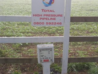
pic2 - Killingholme to Buncefield pipeline coming in to the depot.

pic 2a - same pipeline, but the other (western) side of the road - not the directional indicator, ie the flow of the oil is away from the viewer, that the pipe is 10" wide and that this leg of the journey is 104.6km long. I'm not sure about the S at this stage, but the L- marking indicates that the pipeline contains liquid.
 pic3 - finally, a bit further south we come across our pipeline for the first time. I'm not getting misty-eyed or anything, it was 8:30 in the morning and September, so it was misty on that morning. Note the cobwebs with the dew on them too. This is not marked on the other side of the road like the total one was and is more or less opposite the depot entrance shown in pic1.
So - the pipeline has left the depot (I mean pipeline as a generic term for the three pipes: two marked WLPS bound for Heathrow an one marked UKOP which may or may not be going to Kingsbury or coming from Kingsbury, don't know yet) , which is on the eastern side of Hemel and has entered Crown Estate farmland to the east of the depot, and is presently running east. That pipeline has got to go to Heathrow first (the Kingsbury one doesn't but bear with me for now until we get to Bovingdon where things get 'interesting'), so I guess it had better turn south, which it must do pretty sharpish, as the next road incursion [map3] has it going virtually north-south across the roads.
[As ever: my thanks to the ordnance survey for their wonderful maps, and to multimap for showing them for free. Also, I am no expert on pipelines to any degree whatsoever, all I know is what I have picked up from the internet and what I have spotted whilst out and about. Please, if you are involved in the oil industry, or have any knowledge of the WLPS please leave a comment and point out any glaring errors or areas of over-asumption I may have made!!] ¶ 1:05 pm
We drove up to the depot first thing in the morning, it was shrouded in mist, and I must admit I did feel a bit dodgy, parking up and taking pics there. To be honest I always feel a bit furtive and dodgy doing this. What must people think this bloke standing there with his camera and his sat nav, taking pics of marker posts? More of this later.
 So, here's the main entrance to the depot [pic1] , and there are two others on the western side I think. Note the security cameras (not pointing at me) and the depot was open, but no one was about. The map shows a left turn at the top of the depot, but this was blocked off [as shown in map1] For more about the depot itself please see this emergency plan document.
Map 1.
Here's the depot. Where do the pipes come in and out? You would think that there would be some sort of sign saying "the start of the trek to Heathrow" - but no. Actually, the first pipeline marker you come across isn't our one at all, but the one I previously referred to, which is bringing oil in from the refinery at Killingholme. [pic2]. Slightly further up the road [see map 2] our pipeline starts. And whilst the Total line coming in to the depot, makes a bit of a song and a dance about it (that is as much of a song and a dance as you get in the dour world of oil pipelines) our one is just marked with one pink- capped aerial post and no marker posts that I could see.
map 2


pic2 - Killingholme to Buncefield pipeline coming in to the depot.

pic 2a - same pipeline, but the other (western) side of the road - not the directional indicator, ie the flow of the oil is away from the viewer, that the pipe is 10" wide and that this leg of the journey is 104.6km long. I'm not sure about the S at this stage, but the L- marking indicates that the pipeline contains liquid.
 pic3 - finally, a bit further south we come across our pipeline for the first time. I'm not getting misty-eyed or anything, it was 8:30 in the morning and September, so it was misty on that morning. Note the cobwebs with the dew on them too. This is not marked on the other side of the road like the total one was and is more or less opposite the depot entrance shown in pic1.
So - the pipeline has left the depot (I mean pipeline as a generic term for the three pipes: two marked WLPS bound for Heathrow an one marked UKOP which may or may not be going to Kingsbury or coming from Kingsbury, don't know yet) , which is on the eastern side of Hemel and has entered Crown Estate farmland to the east of the depot, and is presently running east. That pipeline has got to go to Heathrow first (the Kingsbury one doesn't but bear with me for now until we get to Bovingdon where things get 'interesting'), so I guess it had better turn south, which it must do pretty sharpish, as the next road incursion [map3] has it going virtually north-south across the roads.
[As ever: my thanks to the ordnance survey for their wonderful maps, and to multimap for showing them for free. Also, I am no expert on pipelines to any degree whatsoever, all I know is what I have picked up from the internet and what I have spotted whilst out and about. Please, if you are involved in the oil industry, or have any knowledge of the WLPS please leave a comment and point out any glaring errors or areas of over-asumption I may have made!!] ¶ 1:05 pm
