I have found an excellent document which shows that there is a spur from Thameside aka Coryton to Buncefield, whilst the remainder of the pipeline continues to Kingsbury. Therefore when you are looking at the pipeline spur, then the arrows are going to point towards Buncefield. Whilst not on the spur the directional indicator whilst the remainder of the arrows are going to point away from the Buncefield terminal.
This would mean that the 'T'-junction spur will occur between the two marker posts with different directions on. The diagram below shows it well. Now just to locate the line coming in from the east and to work out where the spur is.
 ¶ 12:30 am 0 comments


map 4
Map 4 shows us its potential journey. It will either cross the road by Westwick Row (called unsurprisingly Westwick Row) or the A4147 Hemel to St Albans road.
The only way of being certain was to drive all the way down Westwick Row and then to turn left onto the surprisingly busy A4147.
Nothing down the medieval Westwick Row, but then, low and behold, shortly before it crosses the M1 there is the pipeline. Pic 8 and 8a show the marker posts, map 5 shows the location.

map 5

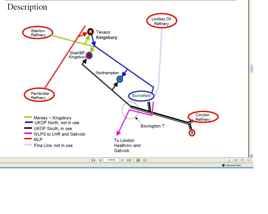
pic 8 - these are the markers on the northern side of the A4147 - spot the CP post - more on that below. Note the UKOP pipeline marker on the left. The directional indictator shows it is running in the opposite direction to all of the others. From memory, this is the only one showing the flow towards Buncefield. According to the Linewatch website, this is the actual direction of the flow, as it should run from the Kingsbury terminal to Buncefield. If this is the case however why do all of the other UKOP pipeline markers show the flow going to Kingsbury? I am really not sure about this. The first Buncefield enquiry neatly summarises all of the pipes and what goes where:
To Buncefield:
- 10" Finaline pipeline from Lindsey
- 10" Pipeline from Merseyside
- 14" From Thames (Coryton as it is known) to Kingsbury terminal (in Warwickshire) with a spur line to Buncefield - aha! This is clearly our one. We will see where the spur comes from and splits later on, but this does suggest that the pipeline direction should be to Buncefield rather than away, opposite to the two lines going to Heathrow. Another inconsistency - or gap in knowledge - the 14" pipeline markers to/from Buncefield are described in the report(s) as the T/K line (Thameside - Kingsbury??) whereas on all of the markers it is marked as T/M (Thameside -??? )
The T/M line is also shown as being on leg 1A (newly placed stickers - I am sure it was just 1 the first time I checked earlier in 2006) and that it is 88.8km long. Well I wonder if this spur goes to Northampton? This is about 90km away from this point.
The third report describes the split as: "14” pipeline from Thameside via a tee junction close to the site – the Hemel Tee (T/K South), which terminates in the BPA main site."

pic 8a southside - was dodging the cars and the boy was in the car, so I couldn't really cross the road to see if there were marker posts there too.
Now, back to the CP post we saw in pic8. Any ideas what that stands for? Well, after digging around a bit (not literally) I found it stands for Cathodic Protection, which to cut a very long story short - aims to prevent corrosion on the buried pipeline. Another explanation is here.
So now we know where the pipeline enters and exits this stretch. Is there any evidence of it 'on the ground' as it were? We can see from the map that a public footpath crosses the field that the pipeline must cross somewhere. I wondered if it would be marked any where - would there be an ariel marker post at field edges/boundaries? As there were other walkers around (bizarrely) and Pipeline Pete jnr was fading fast, I had limited scope for going 'off piste'. So I walked the path and looked for any posts, or failing that some obvious gaps in hedgerow or any hints at all.

pic 9 - here is a big blank path which bisects the footpath - no clues as to being a pipeline though, and crucially, it does not abut the motorway, which would be the logical (?? who am I to say?) route to put it.
I carried on - and at the end of the footpath, where it ends and meets the M1 is a newly built fence. Beyond the fence was a relatively recent mounds of earth, presumably again to do with the widening. One thing I noticed at the time, and thinking about it now it is pretty obvious, is there was a pink tag on one of the fence posts, about 30 yards north of the intersection with the footpath and the M1. Surely this is indicating that the pipeline is running beneath or near. The fence in question is shown in pic10.
 pic 10

pic11 - this is the view from the opposite direction - the fence in pic10 continues on the left of the picture, just out of view. You can see one of the overhead gantries on the M1 though, if that's any consolation.
If I were to walk the 'fence' in that field, I suspect I might see a few more fence posts with pink paint on - if I were to guess - I would say the pipeline runs close to the M1 - my pure conjecture is shown in map 6, below:

map 6 ¶ 3:39 pm 0 comments
